10 WAYS TO LOAD DATA INTO POSTGRES
Regina Obe and Leo Hsu
http://www.paragoncorporation.com
Buy our books! at http://postgis.us/page_buy_book
Our latest book

Categories of loading we'll cover
Server-Side- SQL COPY / COPY FROM PROGRAM
- Large Object storage SQL functions
- Foreign Data Wrappers (FDWs)
Client-Side
- PSQL \copy and \copy FROM PROGRAM
- PSQL Large Object support functions
- Other commandline tools: ogr2ogr, shp2pgsql
- Need not be on same server as Postgres service
Loading delimited files with SQL COPY (Server Side)
- postgres daemon account needs to have access to files
- User has to have super user rights to Postgres service
Step 1: Create staging table
Has to match the structure of the file. Using film locations - https://data.sfgov.org/api/views/yitu-d5am/rows.csv?accessType=DOWNLOAD
CREATE TABLE film_locations
   (title text ,
    release_year integer ,
    locations text ,
    fun_facts text ,
    production_company text ,
    distributor text ,
    director text ,
    writer text ,
    actor_1 text ,
    actor_2 text ,
    actor_3 text );
Step 2 (from file): Load the data using SQL COPY
COPY film_locations
FROM '/data_talk/csvs/Film_Locations_in_San_Francisco.csv' HEADER CSV DELIMITER ',';Step 2 (output from program): Load the data using SQL COPY FROM PROGRAM
Requires PostgreSQL 9.3+
COPY film_locations
FROM PROGRAM 'wget -q -O - "$@" "https://data.sfgov.org/api/views/yitu-d5am/rows.csv?accessType=DOWNLOAD"'
    HEADER CSV DELIMITER ',';
Loading delimited files with psql \copy (Client side)
- psql client needs to have access to the files
- User initiating does not need super user rights to database, but needs to have permissions to the files
- Could be slow if postgres server is not on same local network as client.
Step 1: Create staging table
Has to exactly match the structure of the file. Using film locations - https://data.sfgov.org/api/views/yitu-d5am/rows.csv?accessType=DOWNLOAD
CREATE TABLE film_locations
   (title text ,
    release_year integer ,
    locations text ,
    fun_facts text ,
    production_company text ,
    distributor text ,
    director text ,
    writer text ,
    actor_1 text ,
    actor_2 text ,
    actor_3 text );
Step 2: Load the data with \copy FROM
\copy film_locations FROM '/data_talk/csvs/Film_Locations_in_San_Francisco.csv' HEADER CSV DELIMiTER ',';Step 2 alternative: Load the data using \copy FROM PROGRAM
Requires psql compiled for PostgreSQL 9.3+
\copy film_locations FROM PROGRAM 'wget -q -O - "$@" "https://data.sfgov.org/api/views/yitu-d5am/rows.csv?accessType=DOWNLOAD"' HEADER CSV DELIMITER ',';Server Side: Loading Binary files
Loading documents and images into a database table from server's file system.
Use COPY FROM PROGRAM (PostgreSQL 9.3+) in conjunction with Large Object support (LO)
Step 1: Create staging table
CREATE TABLE tmp_docs(file_name text PRIMARY KEY);
Step 2: Get List of files
Pull list from folder with COPY FROM PROGRAM
WindowsCOPY tmp_docs FROM PROGRAM 'dir C:\data /b /S' WITH (format 'csv');COPY tmp_docs FROM PROGRAM 'ls /data/* -R' WITH (format 'csv');Step 2: Add fields to hold file link id and blob of the files
ALTER TABLE tmp_docs ADD COLUMN doc bytea, ADD COLUMN doc_oid oid;Step 3: Load the binary data
-- add the document to large object storage and return the link id
UPDATE tmp_docs SET doc_oid = lo_import(filename);

-- pull document from large object storage
UPDATE tmp_docs SET doc = lo_get(doc_oid);

-- delete the files from large object storage
SELECT lo_unlink(doc_oid)
FROM tmp_docs;
Client Side: Loading Binary files using psql
Loading documents and images into a database table from client's file system.
Use PSQL \copy and \lo_* functions and SQL to generate a load script
Step 1: Create staging table
Note this is same as what we did for the server side approach
CREATE TABLE tmp_docs(file_name text PRIMARY KEY);
Step 2: Get List of files
Pull list from folder with PSQL \copy FROM PROGRAM (psql packaged with 9.3+)
Windows\copy tmp_docs FROM PROGRAM 'dir C:\data /b /S' WITH (format 'csv');\copy tmp_docs FROM PROGRAM 'ls /data/*' WITH (format 'csv');Step 2: Add fields to hold file link id and blob of the files
ALTER TABLE tmp_docs ADD COLUMN doc bytea, ADD COLUMN doc_oid oid;Step 3: Generate a load script file
\t on returns only tuples (no header), and \x off turns off expanded mode, and \a toggles axis align
\o /temp/loadscript.psql
\t on
\x off
\a
SELECT '\lo_import ' || quote_literal(replace(file_name, '\', '/'))
|| '
UPDATE tmp_docs SET doc_oid = :LASTOID
    WHERE  file_name = ' || quote_literal(file_name) || ';'
FROM tmp_docs;
\oStep 4: run the load script file generated in step 3
the load script file will look something like this
\lo_import '/scans/file1.pdf'
UPDATE tmp_docs SET doc_oid = :LASTOID
    WHERE  file_name = E'/scans/file1.pdf';
\lo_import '/scans/file2.pdf'
UPDATE tmp_docs SET doc_oid = :LASTOID
    WHERE  file_name = E'/scans/file2.pdf';
run the load script file generated in step 3
\i /temp/loadscript.psqlStep 5: Same as server side, using server side functions grab the blob and delete the file from large storage
-- pull document from large object storageUPDATE tmp_docs SET doc = lo_get(doc_oid);
-- delete the files from large object storage
SELECT lo_unlink(doc_oid)
FROM tmp_docs;Using Foreign Data Wrappers to load data
- file_fdw: use to read flat files and flat outputs. New in PostgreSQL 10 can read from commandline programs
- postgres_fdw: use to query other postgres servers
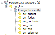
- ogr_fdw - use to query and load spatial formats and also other relational and flat (e.g. spreadsheets, odbc data sources, dbase files, openstreetmap data
- file_text_array - loads each row of data into an array - great where number of columns on each row is not the same like data consisting of orders on one row followed by line items.
- Honorable mentions: multicorn, odbc_fdw, mysql_fdw, oracle_fdw, db2_fdw, tds_fdw
file_fdw
- https://www.postgresql.org/docs/current/static/file-fdw.html
- Generally available with most PostgreSQL packages, may require installing postgresql-contrib if no by default included
- Requires super user to create a foreign table, but user mappings control access.
- New in PostgreSQL 10: can read from output of programs similar to COPY FROM PROGRAM.
Step 1: Install Extension and Create file_fdw Foreign Server
CREATE EXTENSION file_fdw;
CREATE SERVER svr_file FOREIGN DATA WRAPPER file_fdw;
Step 2 (file version): Create Foreign Table to a file system file
CREATE FOREIGN TABLE fdt_film_locations
   (title text ,
    release_year integer ,
    locations text ,
    fun_facts text ,
    production_company text ,
    distributor text ,
    director text ,
    writer text ,
    actor_1 text ,
    actor_2 text ,
    actor_3 text )
    SERVER svr_file
    OPTIONS ( format 'csv', header 'true',
        filename '/data_talk/csvs/Film_Locations_in_San_Francisco.csv',
        delimiter ',',
        null '');
Step 2 (program version): Create Foreign Table from program output
Requires PostgreSQL 10+. This will pull the website data on every query of table.
CREATE FOREIGN TABLE fdt_film_locations
   (title text ,
    release_year integer ,
    locations text ,
    fun_facts text ,
    production_company text ,
    distributor text ,
    director text ,
    writer text ,
    actor_1 text ,
    actor_2 text ,
    actor_3 text )
    SERVER svr_file
    OPTIONS ( format 'csv', header 'true',
     program 'wget -q -O - "$@" "https://data.sfgov.org/api/views/yitu-d5am/rows.csv?accessType=DOWNLOAD"',
     delimiter ',',
     null '');
postgres_fdw: Read from other postgres servers
- Part of standard extension offering so should already have the binaries
- Can read from higher/lower postgres versions, but some features are disabled if both not of same higher version.
- Requires super user to create a foreign table, but user mappings control access.
- New in PostgreSQL 10: Aggregates can be pushed down, which means things like COUNT(*), MAX(*) etc are much faster across databases. More joins can be pushed to remote server thus making cross joins between two databases faster.
Step 1:Install the extension in your database
CREATE EXTENSION postgres_fdw;Step 2:Create Foreign Server
CREATE SERVER remote_db
 FOREIGN DATA WRAPPER postgres_fdw
 OPTIONS (host 'faraway.host.com', dbname 'db', port '5432');
Step 3:Create User Mappings (can be a group or user)
CREATE USER MAPPING FOR public SERVER remote_db OPTIONS (user 'pubinfo', password 'secret');Step 4:Link in the tables
CREATE SCHEMA remote_public;
-- requires PostgreSQL 9.5
IMPORT FOREIGN SCHEMA public FROM SERVER remote_db INTO remote_public;
PostgreSQL + GDAL (OGR) ~ PostGIS = OGR_FDW
PostgreSQL More than Spatial Foreign Data Wrapper
Doesn't require PostGIS to use, but will expose spatial columns as PostGIS geometry if PostGIS is installed.

Use ogr_fdw extension
If you have all sorts of data of both a spatial and non-spatial flavor to tame, make sure you have ogr_fdw foreign data wrapper in your tool belt.
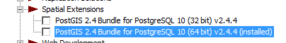
- For windows users using EDB distribution, it's part of PostGIS bundle (versions 2.2 and up) on application stackbuilder.
- For windows/linux/mac desktop users, it's part of the BigSQL PostGIS package.
- For CentOS/Red Hat/Scientific etc, it's available via yum.postgresql.org
- Available via debian and apt.postgresql.org
- For others, if you have PostGIS with GDAL support, just need postgresql dev package to compile. Download the source https://github.com/pramsey/pgsql-ogr-fdw
What can ogr_fdw read?
You have the combined power of Geospatial Data Abstraction Layer (GDAL), PostgreSQL, and any PostgreSQL extension you want (including PostGIS) working seamlessly together. So many kinds of data you can query and take advantage of PostgreSQL functions and any extension functions and types such as PostGIS, hstore, built-in json/jsonb to tame your data.
- Spreadsheets
- ODBC datasources
- Other relational
- OSM files (OSM, PBF)
- Dbase files
- ESRI Shapefiles
- Spatial web services
- Many more
Install Binaries
Make sure to use version for your PostgreSQL, examples below are for 10
- Yum (CentOS, RedHat going via yum.postgresql.org) -
yum install ogr_fdw10 - Debian/Ubuntu (via apt.postgresql.org) -
apt install postgresql-10-ogr-fdw - Windows via application Stackbuilder - included as part of PostGIS bundle 2.2 and above bundles
 .
. - BigSQL (linux/windows/Mac) - included as part of the PostGIS install:
pgc install postgis24-pg10
Enable it in your database
CREATE EXTENSION ogr_fdw;Load in folder of CSV files
CREATE SCHEMA IF NOT EXISTS staging;
CREATE SERVER svr_csv FOREIGN DATA WRAPPER ogr_fdw
OPTIONS (datasource '/fdw_data/csvs', format 'CSV');
-- requires PostgreSQL 9.5+
IMPORT FOREIGN SCHEMA ogr_all FROM SERVER svr_csv INTO staging;
Other relational databases
Format for SQL Server ODBC 'ODBC:your_user/your_password@yourDSN,table1,table2'. ODBC can be slow with a lot of tables (more than 150) so filter list if you have over 200 tables
CREATE SERVER svr_sqlserver FOREIGN DATA WRAPPER ogr_fdw
OPTIONS (datasource 'ODBC:pguser/whatever@MSSQLTest,dbo.IssueLog,dbo.IssueNotes',
format 'ODBC'
);
CREATE SCHEMA IF NOT EXISTS ss;
IMPORT FOREIGN SCHEMA "dbo."
FROM SERVER svr_sqlserver INTO ss;
\dE ss.*List of relations Schema | Name | Type | Owner --------+----------------+---------------+---------- ss | dbo_issuelog | foreign table | postgres ss | dbo_issuenotes | foreign table | postgres (2 rows)
Spreadsheets
Each workbook is considered a server and each sheet a table
CREATE SERVER svr_currency_rates
   FOREIGN DATA WRAPPER ogr_fdw
  OPTIONS (datasource '/fdw_data/ExchangeRates.xlsx',format 'XLSX',
    config_options 'OGR_XLSX_HEADERS=FORCE');
CREATE SCHEMA staging;
-- link only 2 spreadsheets preserve headers (requires PostgreSQL 9.5 to use IMPORT FOREIGN SCHEMA)
IMPORT FOREIGN SCHEMA ogr_all  LIMIT TO (EUR, USD)
	FROM SERVER svr_currency_rates INTO staging
OPTIONS (launder_column_names 'false');file_text_array: Loading delimited files and jagged files with file_text_array
- Usually not available from distros but fairly easy compile
- We have a windows 32/64-bit builds https://tinyurl.com/y8bojebk
- Source code here: https://github.com/adunstan/file_text_array_fdw (note different branch for each version of PostgreSQL)
- New in PostgreSQL 10: can read from output of programs similar to COPY FROM PROGRAM.
step 1: Create Extension and Server
CREATE EXTENSION file_textarray_fdw;
CREATE SERVER file_ta_server FOREIGN DATA WRAPPER file_textarray_fdw;
CREATE USER MAPPING FOR public SERVER file_ta_server;
step 2 (file version): Create FOREIGN TABLE
CREATE FOREIGN TABLE fdt_film_locations_ta( x text[] ) SERVER file_ta_server
OPTIONS (filename '/data_talk/csvs/Film_Locations_in_San_Francisco.csv', encoding 'latin1', delimiter E',');
step 2 (program version): Create FOREIGN TABLE
Requires PostgreSQL 10+
CREATE FOREIGN TABLE fdt_film_locations_ta( x text[] ) SERVER file_ta_server
OPTIONS (program 'wget -q -O - "$@" "https://data.sfgov.org/api/views/yitu-d5am/rows.csv?accessType=DOWNLOAD"', encoding 'latin1', delimiter E',');
Commandline Tools
Commonly available Open source command-line when you have PostgreSQL / PostGIS installed.
- shp2pgsql- use to load Dbase and ESRI shapefiles, generally part of based postgis or postgis-gui package
- ogr2ogr - Binaries and packages available for most server and Desktop OS ( https://trac.osgeo.org/gdal/wiki/DownloadingGdalBinaries ). Use to load any kind of data, specially designed for spatial vector data.
shp2pgsql
Part of PostGIS project, often packaged separately as postgis-gui. On EDB Windows Stackbuilder, part of PostGIS bundle. On BigSQL part of postgis package.
Pipe to psql for load
export PGPORT=5432
export PGDATABASE=pgopen2018
export PGUSER=postgres
export PGPASSWORD=xxxx
exportPGHOST=localhost
shp2pgsql -s 4269 -D -d data\BART_Lines\Bart_13 bart_lines | psql
Output as an sql script
shp2pgsql -s 4269 -D -d > bart_lines.sqlogr2ogr: Swiss army knife for data loading
ogr2ogr --formatsSupported Formats: JP2ECW -raster,vector- (rov): ERDAS JPEG2000 (SDK 5.3) OCI -vector- (rw+): Oracle Spatial SOSI -vector- (ro): Norwegian SOSI Standard PCIDSK -raster,vector- (rw+v): PCIDSK Database File netCDF -raster,vector- (rw+s): Network Common Data Format JP2OpenJPEG -raster,vector- (rwv): JPEG-2000 driver based on OpenJPEG library PDF -raster,vector- (rw+vs): Geospatial PDF DB2ODBC -raster,vector- (rw+): IBM DB2 Spatial Database ESRI Shapefile -vector- (rw+v): ESRI Shapefile MapInfo File -vector- (rw+v): MapInfo File UK .NTF -vector- (ro): UK .NTF OGR_SDTS -vector- (ro): SDTS S57 -vector- (rw+v): IHO S-57 (ENC) DGN -vector- (rw+): Microstation DGN OGR_VRT -vector- (rov): VRT - Virtual Datasource REC -vector- (ro): EPIInfo .REC Memory -vector- (rw+): Memory BNA -vector- (rw+v): Atlas BNA CSV -vector- (rw+v): Comma Separated Value (.csv) NAS -vector- (ro): NAS - ALKIS GML -vector- (rw+v): Geography Markup Language (GML) GPX -vector- (rw+v): GPX LIBKML -vector- (rw+v): Keyhole Markup Language (LIBKML) KML -vector- (rw+v): Keyhole Markup Language (KML) GeoJSON -vector- (rw+v): GeoJSON Interlis 1 -vector- (rw+): Interlis 1 Interlis 2 -vector- (rw+): Interlis 2 OGR_GMT -vector- (rw+): GMT ASCII Vectors (.gmt) GPKG -raster,vector- (rw+vs): GeoPackage SQLite -vector- (rw+v): SQLite / Spatialite ODBC -vector- (rw+): ODBC WAsP -vector- (rw+v): WAsP .map format PGeo -vector- (ro): ESRI Personal GeoDatabase MSSQLSpatial -vector- (rw+): Microsoft SQL Server Spatial Database OGR_OGDI -vector- (ro): OGDI Vectors (VPF, VMAP, DCW) PostgreSQL -vector- (rw+): PostgreSQL/PostGIS MySQL -vector- (rw+): MySQL OpenFileGDB -vector- (rov): ESRI FileGDB XPlane -vector- (rov): X-Plane/Flightgear aeronautical data DXF -vector- (rw+v): AutoCAD DXF CAD -raster,vector- (rovs): AutoCAD Driver Geoconcept -vector- (rw+): Geoconcept GeoRSS -vector- (rw+v): GeoRSS GPSTrackMaker -vector- (rw+v): GPSTrackMaker VFK -vector- (ro): Czech Cadastral Exchange Data Format PGDUMP -vector- (w+v): PostgreSQL SQL dump OSM -vector- (rov): OpenStreetMap XML and PBF GPSBabel -vector- (rw+): GPSBabel SUA -vector- (rov): Tim Newport-Peace's Special Use Airspace Format OpenAir -vector- (rov): OpenAir OGR_PDS -vector- (rov): Planetary Data Systems TABLE WFS -vector- (rov): OGC WFS (Web Feature Service) HTF -vector- (rov): Hydrographic Transfer Vector AeronavFAA -vector- (rov): Aeronav FAA Geomedia -vector- (ro): Geomedia .mdb EDIGEO -vector- (rov): French EDIGEO exchange format GFT -vector- (rw+): Google Fusion Tables SVG -vector- (rov): Scalable Vector Graphics CouchDB -vector- (rw+): CouchDB / GeoCouch Cloudant -vector- (rw+): Cloudant / CouchDB Idrisi -vector- (rov): Idrisi Vector (.vct) ARCGEN -vector- (rov): Arc/Info Generate SEGUKOOA -vector- (rov): SEG-P1 / UKOOA P1/90 SEGY -vector- (rov): SEG-Y XLS -vector- (ro): MS Excel format ODS -vector- (rw+v): Open Document/ LibreOffice / OpenOffice Spreadsheet XLSX -vector- (rw+v): MS Office Open XML spreadsheet ElasticSearch -vector- (rw+): Elastic Search Walk -vector- (ro): Walk Carto -vector- (rw+): Carto AmigoCloud -vector- (rw+): AmigoCloud SXF -vector- (ro): Storage and eXchange Format Selafin -vector- (rw+v): Selafin JML -vector- (rw+v): OpenJUMP JML PLSCENES -raster,vector- (ro): Planet Labs Scenes API CSW -vector- (ro): OGC CSW (Catalog Service for the Web) VDV -vector- (rw+v): VDV-451/VDV-452/INTREST Data Format GMLAS -vector- (rwv): Geography Markup Language (GML) driven by application sc hemas TIGER -vector- (rw+v): U.S. Census TIGER/Line AVCBin -vector- (ro): Arc/Info Binary Coverage AVCE00 -vector- (ro): Arc/Info E00 (ASCII) Coverage HTTP -raster,vector- (ro): HTTP Fetching Wrapper
ogr2ogr load data into PostgreSQL
Can use psql variables or be specified on commandline
Load an OpenStreetMap protobuf file
ogr2ogr -f "PostgreSQL" \
	"PG:host=localhost user=postgres password=xxx dbname=pgopen2018" sf.osm.pbf
Load a folder of CSV files (folder is called csvs)
ogr2ogr -f "PostgreSQL" \
	"PG:host=localhost user=postgres password=xxx dbname=pgopen2018" /data_csv